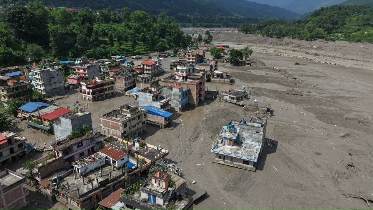
On August 26, a wall of water, ice, rock, and debris descended through the trans-Himalayan river system, transforming the Bhotekoshi-Trishuli corridor into a site of destruction. Settlements disappeared, roads and bridges were swept away, and hydropower and irrigation infrastructure was devastated. Families lost not only their houses and livelihoods, but also places to which generations of memories and belongings had been attached. Our deepest condolences go to the families who have lost their loved ones, and our thoughts remain with those still waiting for news of missing family members.
As of September 19, the total deaths stood at 1,411 while another 5,875 people remained missing, according to data from the National Disaster Risk Reduction and Management Authority. The catastrophe has become one of the gravest water-induced disasters in Nepal's modern history. Public discourse is labeling this catastrophe a “water bomb” and a “Himalayan tsunami,” accompanied by speculation and conspiracy theories. But these dramatic terms do not necessarily help us understand what actually happened. In simple terms, this catastrophe is a “flash flood” associated with a suspected glacier collapse and a rapidly moving mixture of water, ice, sediment, and debris. Preliminary scientific assessments indicate that a large section of a glacier broke away at high altitude and plunged into the valley, mobilizing enormous quantities of material downstream. The precise chain of events and the role of antecedent climatic conditions require careful scientific analysis. Most preliminary findings come from remote sensing data, which require ground-truth verification and validation before researchers can draw definitive conclusions about the causes, processes, and sequence of events.
Civilizations have always developed around rivers because they provide water, fertile land, transportation, energy, and livelihoods. But the same proximity that makes rivers the foundation of civilization can become a source of vulnerability when their natural flow is “stressed.” For Nepal, this is particularly complex, as our rivers descend from one of the world's most fragile mountain environments. Many originate in snow- and glacier-dominated catchments and cross international borders before reaching our floodplains. The Bhotekoshi disaster involves one such river that deserves more than grief and reconstruction. It demands a national dialogue about how Nepal understands water governance, climate risk, and development. Yet that conversation is already narrowing around one dominant explanation of climate change. In public discourse, including among experts, opinion makers, politicians, activists, academics, and ordinary citizens, climate change is increasingly presented as an explanation for the catastrophe. The Government of Nepal is also taking this issue to the UNGA as a primary agenda item. Nepal has every reason to raise the impact of climate change internationally, as it contributes only a tiny fraction of global greenhouse-gas emissions. Yet it faces disproportionate risks from a rapidly changing Himalayan cryosphere. Nepal thus needs justice from the emitters; it is a simple, open-and-shut case.
When glaciers, snow, permafrost, and mountain hydrology are changing, climate change is obviously part of the risk landscape. What we should resist is letting it become a convenient blanket explanation for every other weakness underneath. Climate change does not decide where we construct settlements. It does not approve a hydropower plant, design a bridge, or determine a road alignment. It does not decide whether floodplains are occupied, whether hazard information is incorporated into planning, whether upstream observations are shared across borders, whether warnings reach communities, or whether government institutions can act rapidly when a river behaves outside its historical envelope. These are human decisions and, most importantly, part of the governance mechanism. A disaster results not solely from a hazard but from the interaction of hazard, exposure, vulnerability, and capacity. Attributing every water-induced catastrophe to climate change risks overshadowing failures that largely fall within our own capacity and responsibility to address. The Bhotekoshi disaster therefore requires revisiting our policies, institutions, transboundary water diplomacy, infrastructure planning, science-policy interface, and disaster preparedness. Understanding these is essential not only to learn from this catastrophe, but also to build a stronger foundation for managing emerging water-related risks in the future. This article therefore explores beyond climate change to examine the wider factors that turned the Bhotekoshi hazard into a catastrophe.
Entangled policies and responsibilities
Overlapping authority and an unclear chain of command during the Bhotekoshi disaster made the response appear as though no governing framework existed for a crisis of this scale. However, Nepal has well-defined disaster laws, policies, and institutional frameworks. The Disaster Risk Reduction and Management Act 2017 establishes responsibilities across federal, provincial, and local levels. Federal authorities manage resource allocation, institutional capacity building, disaster planning, and coordination. Provincial authorities handle preparedness, coordination, relief, and recovery. Local governments handle key functions such as disaster planning, emergency exercises, local early-warning systems, and emergency operation centers. In addition, Nepal has laws and policies covering water resources, watershed conservation, land use, environmental assessment, infrastructure, and disaster-risk reduction. They share responsibility for local embankments, river and landslide control, mapping disaster-risk areas, identifying vulnerable settlements, and coordinating disaster-risk reduction.
However, this governance fails to translate into a coherent operational system when an unprecedented disaster crosses municipalities, districts, sectors, and national borders. Our water governance architecture remains largely administrative, while the hazard itself is hydrological, transboundary, and systemic. A glacier does not recognize a municipality's jurisdiction. A debris flow does not stop where one ministry's mandate ends and another begins. A flood traveling through a transboundary river corridor does not wait for federal, provincial, and local governments to decide whose responsibility has begun. This is where coordination becomes more than an administrative concern and requires serious policy attention. When a catastrophe overwhelms several local governments simultaneously, who assumes operational leadership? At what threshold does the province mobilize additional resources? When does the federal government activate extraordinary technical capacity? Who maintains a common operational picture? Who decides where to deploy equipment, rescue personnel, medical services, and supplies?
Position of transboundary water diplomacy
Nepal occupies a central position in the regional hydrological system, downstream of China and upstream of India. It maintains longstanding political and diplomatic relations with both countries, yet water diplomacy has not kept pace with the growing complexity of emerging transboundary risks. For Himalayan rivers, conventional diplomacy and periodic administrative exchanges are no longer sufficient. Effective cooperation requires continuous scientific exchange, hydrometeorological and cryospheric monitoring, real-time data sharing, mutually understood warning protocols, and institutional mechanisms capable of acting promptly. Transboundary water diplomacy thus requires moving away from a traditional benefit-sharing approach to data sharing, risk sharing, and warning sharing. Nepal should therefore strengthen specialized water-diplomacy capacity within its foreign-policy architecture, whether through dedicated water envoys or another permanent technical mechanism. This mechanism should connect diplomacy with hydrology, meteorology, cryosphere science, infrastructure planning, and disaster-risk management.
Weakened institutional capacity?
Nepal once had a dedicated Department of Water-Induced Disaster Management (DWIDM), established in 2000 to manage casualties and infrastructure losses from water-induced disasters. During subsequent restructuring, the DWIDM was merged into the Department of Irrigation, creating the Department of Water Resources and Irrigation. The former department itself was inadequate, given its limited mandate and predominantly infrastructure-focused approach. However, for a country highly exposed to water-induced disasters, dedicated institutional capacity remains essential in a stronger form. Without such dedicated institutions, the questions remain: Who now maintains national expertise in catastrophic flood hydraulics, debris flows, and cascading river hazards? Where is the institutional home for integrated assessment of glacier-related hazards and their downstream consequences? Which organization has sufficient specialists, equipment, modeling capability, field presence, budget, and legal authority to respond immediately to an event of this magnitude? These questions deserve an independent institutional audit.
Lagging science-policy interactions
Universities and research institutions in Nepal and abroad have significantly advanced the science and technology for understanding water-related hazards. Satellite observations, remote sensing, hydrometeorological monitoring, and numerical modeling have advanced significantly. They now allow us to track glaciers and glacial lakes, detect landscape changes, model river behavior, and identify exposed infrastructure with unprecedented detail. However, this scientific capability has yet to translate into policy and practice. No adequate institutional mechanism exists for scientific evidence to routinely inform policymakers or for policymakers to communicate priority knowledge needs back to researchers. All of this is routed through procedural bureaucratic mechanisms, creating delays and two-way communication gaps. Thus, the major challenge we face today is no longer simply producing better science, but ensuring that science reaches policy, policy shapes preparedness, and preparedness reaches people before the flood does.
Digital proliferation but lagging disaster literacy
Even if science and policy interact effectively, the chain remains incomplete unless knowledge reaches the people at risk. The best forecasting and early-warning systems have little value if communities cannot understand, trust, or act on the information they receive. The scale of the casualties and the accounts of survivors showed that the public lacks another critical infrastructure: disaster literacy. Survivors reported that most casualties occurred when people remained dangerously close to the unfolding hazard to record it on their mobile phones. Ironically, the phones could have served as a lifeline for receiving and transmitting warnings, evacuation alerts, and critical information. Although Nepal's disaster legislation envisages integrating disaster-management education from schools, this provision must translate into practical preparedness. Communities along vulnerable river corridors should understand warning signals, abnormal river behavior, evacuation routes, and basic flash-flood safety. For this, schools should conduct regular drills, and municipalities should identify vulnerable settlements and communicate clear evacuation procedures before emergencies occur. Disaster literacy should therefore be treated as an essential component of disaster-resilient infrastructure, alongside forecasting systems, protective structures, and emergency response capacity.
Need for transformative infrastructure policy
One uncomfortable lesson lies in Nepal’s approach to infrastructure development. For decades, progress has been measured largely through indicators such as kilometers of roads, numbers of bridges, megawatts of hydropower, and expansion of urban infrastructure. The whole infrastructure sector merely follows the principle: “Build. Build faster. Build more.” The problem is not construction itself, but the tunnel vision through which it is often planned. A bridge may meet structural standards yet sit within a poorly understood river corridor. A hydropower plant may be technically sound but exposed to cascading upstream hazards, and a road may meet engineering specifications while destabilizing slopes or disrupting natural drainage. This approach has placed a heavy burden on our resources for infrastructure operation and maintenance. Nepal therefore needs to move from “structure-centered engineering to system-based infrastructure planning.” To do so, current environmental impact assessments must also move beyond procedural compliance and be complemented by strategic environmental assessment, cumulative-impact assessment, and basin-scale planning. Most importantly, Nepal must redefine project boundaries. A project boundary is not necessarily its risk boundary, especially for water infrastructure in snow-fed catchments. The hydrological and hydraulic risks may extend far upstream and downstream. Nepal therefore needs a “transformative infrastructure policy” that provides an overarching, risk-informed framework across sectors, shifting the focus from simply “how much we build” to where, how, and under what future risks we build.
Redefining river setbacks
In September 2026, Nepal’s Supreme Court, while addressing floodplain encroachment, asserted that “rivers have rights.” This ruling brings to the forefront one of Nepal’s most politically difficult water-governance questions: “Who owns the floodplain?” For too long, we have viewed rivers through a static administrative lens, drawing fixed boundaries around systems that are inherently dynamic. A river is not simply the flow line occupied by water under ordinary conditions. Rivers migrate, erode banks, deposit sediment, and periodically occupy their floodplains. Moreover, snow-fed rivers are even more dynamic, capable of dramatically altering their channels and geometry following extreme floods, landslides, and debris flows. However, river corridors continue to be regulated largely through fixed administrative setbacks that inadequately capture this physical reality. A glacier-fed Himalayan torrent, a monsoon-dependent river in the Tarai, an urban river, and a spring-fed hill stream each behave uniquely. So, why should their boundaries be defined identically? Nepal thus needs basin-specific, risk-based, and dynamically mapped river corridors informed by hydrology, hydraulics, geomorphology, sediment dynamics, and projected climatic conditions. Floodplain regulation must become a scientific risk-management instrument, rather than simply an administrative measure based on the use of riverbank conditions.
Reforming relief governance
The extraordinary solidarity shown by the people of Nepal after disasters remains one of the greatest strengths of the country. Citizens mobilize quickly, donating money, food, clothing, medicines, and other essentials to support affected communities. Cash donations are channeled through the centralized Prime Minister Disaster Relief Fund, helping ensure accountability and limit fraudulent fundraising that can exploit public emotions. In-kind (non-cash) assistance is also channeled through a “one-door policy,” under which the District Administration Office scrutinizes and coordinates relief materials. In a disaster of this scale, however, an office already burdened with multiple emergency responsibilities can itself become a bottleneck. When affected communities report shortages of basic necessities despite widespread public willingness to help, the issue is no longer simply one of resource availability, but also of how efficiently assistance is verified, coordinated, and delivered. What is needed, therefore, is coordination without excessive gatekeeping. Local governments, ward offices, and accredited humanitarian organizations should be able to support verification and distribution, backed by a common digital inventory and transparent reporting system. Our relief system should therefore move toward a unified information system rather than a scrutinizing system for humanitarian assistance. Good disaster governance must protect against both corruption and bureaucratic delay because accountability loses its purpose if assistance cannot reach people when they need it most. Our dialogue and discourse must rethink current policies to ensure assistance reaches affected communities in times of need. The relief plan must also include the well-being of affected people and their families.
Climate justice abroad, better governance at home
None of the arguments above diminishes the significance of climate change or the growing risks it poses to Nepal’s fragile mountain environment. Nepal’s mountains are increasingly exposed to the consequences of a changing climate, despite the country having contributed only a negligible share of global greenhouse-gas emissions. Nepal must therefore continue to demand climate justice and greater responsibility from the countries that contributed most to global warming. However, climate justice abroad must be matched by governance responsibility at home.
We cannot control global greenhouse-gas emissions from Kathmandu, but many of the factors that determine vulnerability remain within our control. We can decide where and how infrastructure is built, strengthen floodplain regulation, integrate science into policy, reinforce specialized institutions, clarify operational responsibilities, and improve disaster literacy. We can strengthen transboundary monitoring and early-warning mechanisms and require infrastructure planning to account for future rather than relying solely on historical hydrology. We can also ensure that knowledge produced by researchers does not remain confined to theses, journal articles, and consultancy reports. This matters because if every catastrophe is explained primarily through an external global force, climate change can inadvertently become a convenient explanation through which domestic failures escape scrutiny. Climate change may reshape hazards, but it should never become an excuse to overlook vulnerabilities that are within our capacity to reduce.
Bhotekoshi must become a turning point
The Bhotekoshi catastrophe should not end with simply rebuilding what has been destroyed. Reconstructing the same infrastructure in the same locations, based on the same assumptions, and under the same institutional arrangements would only “reconstruct vulnerability.” Nepal needs a serious national reassessment of snow-fed river corridors, critical infrastructure exposure, and floodplain regulation. Hydropower and road-design assumptions, glacier and upstream hazard monitoring, transboundary data exchange, emergency command structures, and disaster education must also be revisited. Equally important is a permanent institutional bridge connecting science, policy, and practice. The next disaster may not resemble the Bhotekoshi event. It may originate from another glacier, landslide, or temporary natural dam, or result from an unprecedented combination of extreme rainfall, snowmelt, sediment movement, and infrastructure failure. From the Tamor in the east to the Chameliya in the west, Nepal’s snow-fed river systems face different combinations of these evolving risks. We therefore must be prepared for events we have yet to experience.
Climate change may be altering the probability, magnitude, and character of hazards, but the consequences are not determined by the hazard alone. Our development choices shape exposure, infrastructure and settlement decisions shape vulnerability, and our institutions shape preparedness. Moreover, our ability to connect science with policy determines whether knowledge becomes protection. The lesson of Bhotekoshi must therefore go beyond simply concluding that climate change caused another disaster. Nepal cannot stop the Himalayas from changing, but we can stop treating every catastrophe as though nothing could have been done before the water arrived.
(Bishal Dahal, PhD, is a water management and policy researcher at the University of Oulu, Finland, and a senior divisional engineer at the Department of Water Resources and Irrigation, Nepal. Supriya KC is a doctoral researcher at the University of Oulu, Finland.)