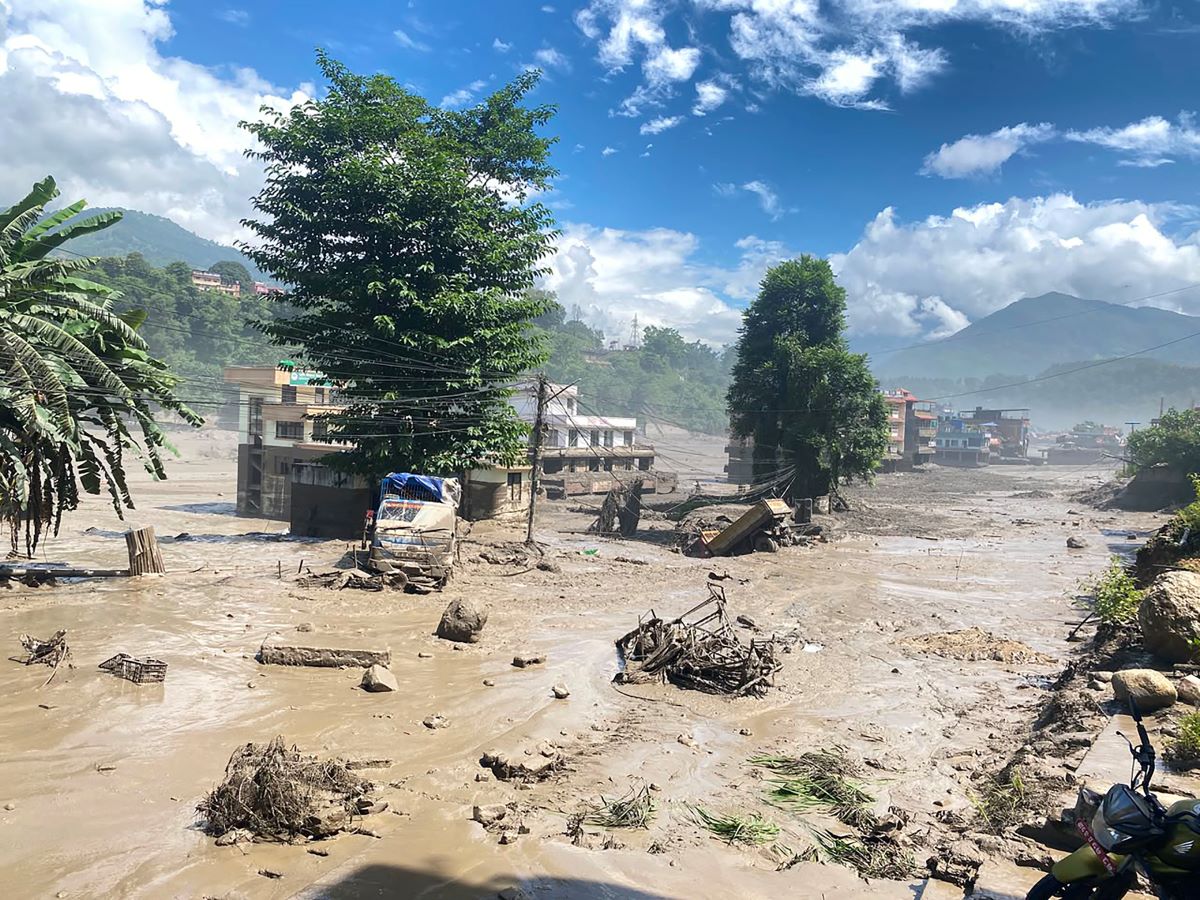
The sudden flooding of the Bhotekoshi River, which has caused significant loss of life and property, has raised questions about what triggered the disaster.
The sudden flood on Wednesday morning caused extensive damage along riverbanks from Rasuwa through Nuwakot and Dhading to Chitwan. It destroyed villages and physical infrastructure of several hydropower projects, Timure Customs Office, as well as numerous houses and bridges. The full extent of the human and material losses has not yet been established.
The Flood Forecasting Division, citing information received from the Chinese side, said the flood occurred after a sudden breach of a blockage or natural dam formed in the river.
The division also warned that the risk remains in the Bhotekoshi and Trishuli areas because part of the blockage has yet to fully clear.
“According to information received from China, the lake formed where the river was blocked has not yet fully drained. Therefore, the risk remains in the Bhotekoshi and Trishuli areas. Until further notice, people are requested to stay in safe locations away from the rivers,” the division wrote on Facebook at around 1:30 p.m. on Wednesday.
Hydrologist Sauharda Joshi of the division said that authorities had not yet determined the exact location where the river was blocked.
“Today’s satellite image has yet to arrive. Once we receive it, we will know exactly where the river was blocked,” he said. “So far, information from Chinese sources indicates that the flood occurred after the blockage suddenly breached.”
He said that the risk remains because the blocked section of the river has not yet completely opened.
According to Joshi, although the water flow no longer appears as powerful as it was initially, the flood continues to pose a similar risk of damage to areas it reaches.
“The level of risk we faced in the morning remains essentially the same. People in downstream areas should remain as alert as they were in the morning,” he said.
The flood, which began at around 8 a.m., continues to cause destruction. To understand what may have caused it, we spoke to experts in geology and meteorology.
Geologist Shreekamal Dwivedi said that there had recently been substantial rainfall in the northern areas of Melamchi and Langtang. The rain may have saturated the soil and caused it to suddenly collapse and flow downstream. Another possibility, he said, is that a dam created in the river by an avalanche or landslide may have burst.
“We have received information that there was significant rainfall in the Langtang and Melamchi’s northern areas. This rainfall itself could have triggered a ‘one-time event’ leading to the flood,” Dwivedi told Setopati. “There are also other possible causes for a flood of this nature. Although it is too early to say exactly, a sudden flood of this magnitude could also have resulted from melting snow or ice, or the collapse of a river blockage created by a glacier.”
He said that a detailed geological study of the area would be necessary to determine the exact cause.
Meteorologist Min Kumar Aryal said that the flood could also have resulted from the bursting of a glacial lake.
“There was rainfall in the Tibet region, but that rainfall alone may not have been enough to produce such a massive flood,” he said. “A glacial lake may have burst, or a dam formed by a blocked river may have collapsed. It is not yet possible to say exactly what happened.”
According to geologist Dwivedi, a sudden, large-volume flood carrying substantial debris in mountainous areas as a result of a glacial lake outburst, melting snow or ice, or similar processes is broadly referred to as a glacial flood.
When glacial lakes began to be studied about two decades ago, such floods were primarily understood to result from glacial lake outburst events. However, Dwivedi said, it has since been established that similar floods can occur because of other factors too.
He identified five major causes of such floods.
Glacial lake outburst
Water from melting glaciers can accumulate and form a glacial lake. When the lake suddenly breaches and releases water at high speed, it is known as a glacial lake outburst flood (GLOF).
There are several ways such an outburst can occur. A large avalanche falling into a lake can cause water to spill over the natural dam holding the lake. The large volume of overflowing water gradually erodes the dam material. As the channel deepens, more water escapes from the lake, further deepening the channel.
As the channel grows deeper, landslides can occur along both sides, widening it further and allowing even more water to escape.
A glacial lake can also burst when its natural dam collapses. Weak geological structure, erosion of the dam material and increased underground water flow through small openings within the dam can cause it to collapse spontaneously.
Dwivedi said that the formation and expansion of glacial lakes has increased over the past few decades, raising the risk of floods downstream when these lakes burst.
“The billions of liters of water released by an outburst, combined with sediment, can cause extensive loss of life and property along rivers downstream of the glacial lake and in lower river valleys,” he said. “The flow from an outburst is extremely powerful. An ordinary flood generally consists mainly of water, with perhaps 5-10 percent sediment. But the faster the water flows, the greater is its capacity to carry larger sediment particles.”
The effects of such flows can extend 10 to 100 kilometers downstream from the glacial lake. Farther downstream, the sediment tends to drop out and the flow becomes more like an ordinary flood.
Glaciers
In high Himalayan areas, snowfall occurs while temperatures remain below freezing point. Snow accumulates over time, with lower layers compressed by the weight of newer snow above them. As the density of the lower layers increases, the snow gradually turns into ice.
“Both snow and ice are solid forms of water. Freshly fallen snow has a density of about 0.01 grams per cubic centimeter, while ice has a density of 0.917 grams per cubic centimeter. Compacted snow has a density somewhere between the two,” he said. “As the snow layer becomes thicker, it gradually begins to move downslope. This is how glaciers form.”
Ice flow
In areas where temperatures remain below zero degree Celsius throughout the year, moisture in the soil outside glaciers can also freeze and become consolidated.
The movement of ice in glaciated areas can carve U-shaped valleys, while water erosion is more commonly associated with the formation of V-shaped valleys.
Heavy rainfall in high Himalayan areas
High Himalayan areas generally receive very little rainfall. For example, Manang receives an average of around 250 millimeters of rainfall annually.
When a large amount of rain falls in a short period in such areas, the relatively warm rainwater can melt snow, ice and frozen ground, potentially triggering a glacial or debris-laden flood.
Floods in India’s Kedarnath region and Nepal’s Mahakali and Melamchi areas in 2013 were examples of this type of event.
Satellite-based rainfall data showed that the Kedarnath area received more than 500 millimeters of rain in one week. Similarly, exceptionally heavy rainfall was recorded in the Melamchi River basin.
In Manang, where annual average rainfall is around 250 millimeters, a 24-hour rainfall total of 82.8 millimeters was enough to contribute to a compound or mixed flow event.
Avalanches
Large avalanches in steep Himalayan terrain can also trigger glacial or debris-laden floods.
The 2003 Madi disaster and the 2012 Seti disaster were attributed to this type of mechanism. According to Dwivedi, avalanches in high Himalayan areas can contain large amounts of fine, accumulated material, and because of the steep terrain, this material can readily mix with water and travel rapidly downstream as a debris-laden flow.